
Comparison
German state geoportals compared
Where can buyers find development plans, ALKIS and Bodenrichtwert data in Germany's sixteen states?
On this page
Three data questions before buying
A Geoportal, an official geodata portal, is rarely just a map. It combines Geobasisdaten, official base geodata, planning information and specialist layers maintained by different offices. For a plot, answer three questions separately: what is legally buildable, where are the parcel and buildings, and which land value is a useful comparison?
The states offer different entry points. One interface may lead directly to Bauleitplanung, planning data, and ALKIS, the official cadastral information system; another may point to a separate Bodenrichtwert, standard land value, service or municipal platform. The portal name matters less than the data date, metadata and responsible office.
- Read the development plan correctly
- Bodenrichtwert as a comparison value
- Why the states offer different entry points
- Workflow for a purchase plot
- Sources and review date
Source: Geoportals, ALKIS and BORIS services of the 16 states; checked August 2026
Read the development plan correctly
A map service may show the outline of a development plan while only linking or summarising its written rules. To assess buildability, read the plan drawing, written provisions, statement of reasons, local by-laws and amendments together. Under § 10 BauGB, the municipality adopts the development plan as a by-law and remains responsible for binding planning.
The query under § 30 BauGB therefore starts with the exact Flurstück (official cadastral parcel) number, and the correct plan version. A coloured layer may show a building line, use category or overlapping rule, but cannot reliably explain whether an exemption, Baulast (public-law building obligation) or exception applies. The zoning and buildability review needs the original documents.
ALKIS is geodata, not the land register
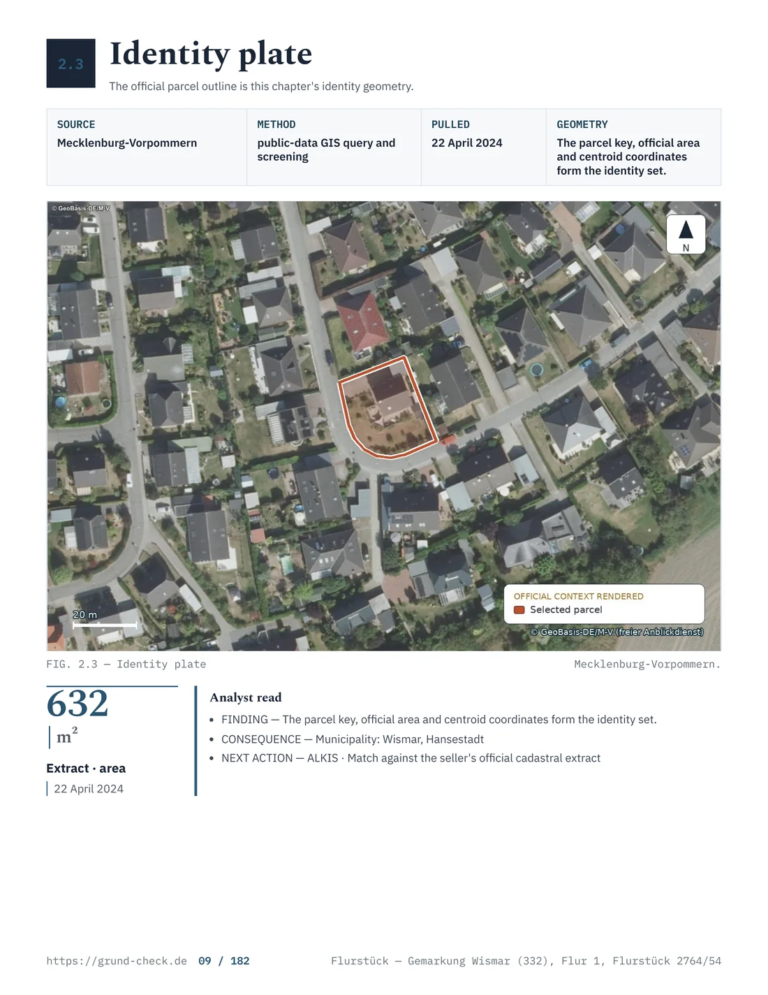
ALKIS describes parcels, location names, actual use and often building outlines. It is highly useful for identifying a plot, but proves neither ownership nor every private boundary. Ownership and charges are recorded in the Grundbuch, the land register; access requires a legitimate interest under, among other rules, § 12 GBO.
A line on an ALKIS screen is not a boundary determination. Scale, generalised geometry, old surveys or an overlay with aerial imagery can make the display inaccurate. For a boundary fence, planned garage or subdivision, involve the responsible survey office or a publicly appointed surveyor. The land register and ALKIS comparison shows which question each system can answer.
Bodenrichtwert as a comparison value
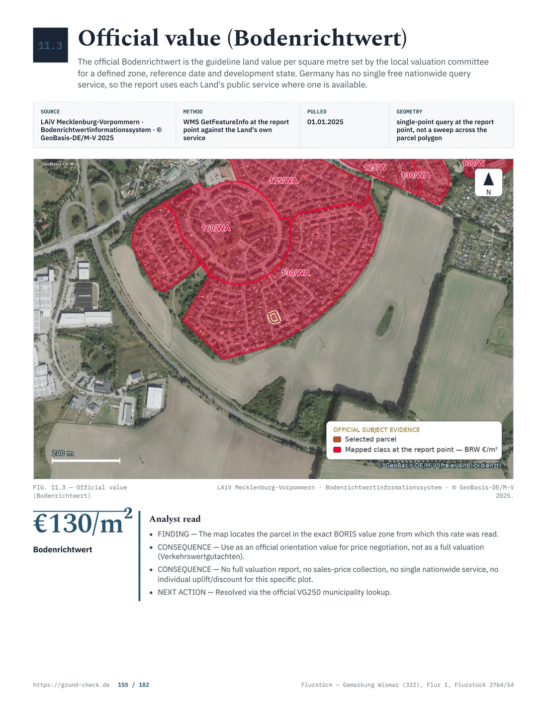
Under § 196 BauGB, Bodenrichtwert describes the average land value for a Bodenrichtwertzone, a standard-land-value zone. It is a statistical reference, not the market value of the individual parcel. Shape, servicing, planning rights, slope, contamination and easements can change the actual value substantially.
The reference date matters. A current figure can relate to a valuation date before the purchase offer. Under § 199 BauGB and related rules, Gutachterausschüsse, valuation committees, work with zones and value-determining features. A free map extract does not replace information containing the full zone characteristics.
- Planning portalMunicipal plan, text and publication
- ALKISParcel identity and geometry
- BORISZone value, reference date and development state
Source: Geoportals, ALKIS and BORIS services of the 16 states; checked August 2026
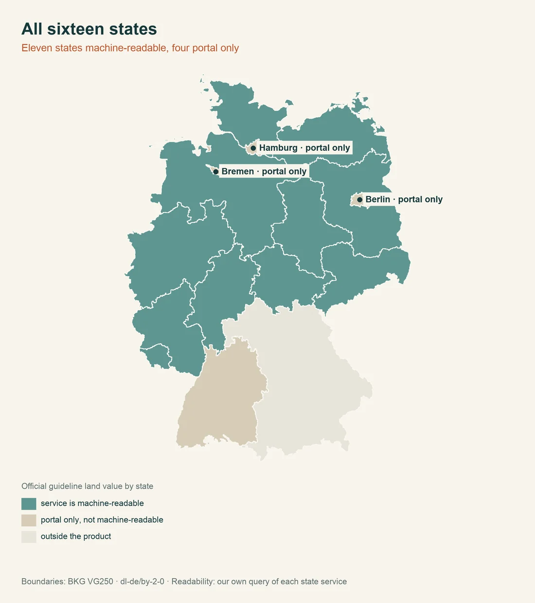
The sixteen state geoportals
The overview gives the official entry point recorded in the datasets for plot checks. Services do not work identically. One state opens a map viewer; another opens metadata with links to ALKIS, planning or Bodenrichtwert services.
| State | Value | Legal basis | Source |
|---|---|---|---|
| Baden-Württemberg | State geoportal: https://www.geoportal-bw.de The portal bundles, among other things, spatial planning, regional plans and land use plans. | § 4 GeoZG BW | Source Baden-Württemberg |
| Bavaria | State-wide geoportal: Geoportal Bayern The portal bundles geodata services, including ALKIS, land use planning and land value services. | Art. 4 BayGDIG | Source Bavaria |
| Berlin | State-wide geoportal: Geoportal Berlin The official site describes the central access to all geodata of the state of Berlin. | § 1 GeoZG Bln | Source Berlin |
| Brandenburg | State-wide geoportal: Geoportal Brandenburg The LGB runs the Geoportal Brandenburg as an official geodata portal. | Geodateninfrastruktur Brandenburg | Source Brandenburg |
| Bremen | State portal: GeoPortal Bremen The GeoPortal Bremen brings together the state's official geodata, including the property cadastre records that have been open since June 2024. | § 3 BremVermKatG | Source Bremen |
| Hamburg | Official geoportal: https://geoportal-hamburg.de/ Operated by Landesbetrieb Geoinformation und Vermessung (LGV). | Geoportal Hamburg; Landesbetrieb Geoinformation und Vermessung | Source Hamburg |
| Hesse | State-wide geoportal: Geoportal Hessen The portal bundles official geodata and map viewers. | § 1 Hessisches Geodateninfrastrukturgesetz | Source Hesse |
| Lower Saxony | State geoportal: https://geoportal.geodaten.niedersachsen.de/ The geodata portal bundles Lower Saxony geodata and services. | § 1 NGDI | Source Lower Saxony |
| Mecklenburg-Western Pomerania | Nationwide geoportal: GeoPortal Mecklenburg-Vorpommern Operated by Landesamt für innere Verwaltung (LAiV) M-V; Central platform for, among other things, parcels of land (ALKIS), standard land values, property tax maps and land use planning. | Geodateninfrastruktur Mecklenburg-Vorpommern (GDI-MV) | Source Mecklenburg-Western Pomerania |
| North Rhine-Westphalia | State-wide geoportal: GEOportal.NRW The portal bundles basic geodata, specialist information and references to BORIS-NRW. | § 3 VermKatG NRW | Source North Rhine-Westphalia |
| Rhineland-Palatinate | Statewide geoportal: GeoPortal.rlp The portal provides official geodata and map viewers for the state. | § 1 LGDIG | Source Rhineland-Palatinate |
| Saarland | State-wide geoportal: GeoPortal Saarland Central access portal to spatial information from the Saarland geodata infrastructure (GDI-SL); according to the English portal page, online since 2010, relaunched on June 29, 2020. | Geodateninfrastruktur Saarland (GDI-SL) | Source Saarland |
| Saxony | State-wide geoportal: Geoportal Saxony Atlas The official portal provides geodata and maps of the Free State of Saxony. | Sächsisches Geodateninfrastrukturgesetz | Source Saxony |
| Saxony-Anhalt | State-wide geoportal: Geodata portal Saxony-Anhalt / Saxony-Anhalt Viewer Official entry to the state's geobase and geotechnical data; the site does not provide an effective date for the portal address. | Geodatenportal Sachsen-Anhalt | Source Saxony-Anhalt |
| Schleswig-Holstein | State geoportal: https://www.geoportal.gdi-sh.de/ The official link list of the state survey refers to the GDI-SH geoportal. | Geodateninfrastruktur Schleswig-Holstein | Source Schleswig-Holstein |
| Thuringia | Statewide geoportal: Geoportal Thüringen The official portal bundles maps, geodata services and nationwide geoinformation. | Thüringer Geodateninfrastrukturrecht | Source Thuringia |
Stand: August 2026. The table identifies the state-wide entry point, not a binding answer for a specific parcel. The responsible service or municipality controls the plan version, boundary and standard-land-value zone.
Why the states offer different entry points
Geodata is organised federally and by subject. State law determines infrastructure and access points, while cadastral offices, valuation committees and municipalities provide their own datasets. Similar information can therefore sit under different menus, or municipal planning may be reachable only through a search map.
City-states have a different administration from territorial states. In Hamburg, Berlin and Bremen, many tasks sit with state or district offices; elsewhere the municipality must provide the binding plan version. A state viewer does not remove that boundary of responsibility.
Check metadata and map date
Before saving a screenshot, record the data date. Check update date, scale, coordinate system, accuracy, service operator and layer licence. With WMS or tile services, the viewer shows a rendered image; metadata explains which object class lies behind it.
For a development plan, record plan name, adoption date and amendment status. For ALKIS, note parcel number, Gemarkung, cadastral district and extract date. For Bodenrichtwert, record valuation date, zone, development status and plot characteristics. This combination makes a later review traceable. Access and provision rules under § 1 and § 3 of the relevant geodata law may differ between states.
A service can be technically reachable and still show old or incomplete data. Check whether the municipality has a newer plan, the survey office an updated extract or the valuation committee a corrected zone. The map is an entry point, not the final authority.
A green symbol or coloured area is not a legal assessment either. Protected areas, flood zones, contaminated sites and monuments may come from different services. The state monument rules and the monument-area search need an additional check with the responsible office.
Workflow for a purchase plot
Start with Gemarkung, Flur and Flurstück. Save the ALKIS extract with its date, open planning data and read the written provisions. Then check the Bodenrichtwert zone, servicing information, protected areas, flood and contamination indicators. This order prevents a plausible land value from obscuring the more important question of usable development rights.
For an unplanned built-up area, § 34 BauGB matters; for the outer area, check § 35 BauGB. An agricultural or nature-protection layer may require an additional approval. Permit-free ancillary structures and rules for sheds and fences help only after the planning status is clear.
Financing also includes land transfer tax by state, tax rates on a purchase, purchase costs and costs before notarisation. Bodenrichtwert is not a substitute for a valuation or price negotiation.
Bring plot data together before buying. A GrundCheck report puts parcel, planning status and visible public-law issues into a reviewable sequence. Check a property.
For boundary questions, add setback rules by state and boundary and survey checks.
Compare the map with original sources. The record stays clear about which statement comes from ALKIS, planning law or Bodenrichtwert. Check a property.
More comparison points are monument protection by state, permit-free building by state and road development contributions by state.
What the map does not prove
A map shows a data representation at a particular time. It proves no ownership, secured access, servicing or building eligibility. Property-law review also requires the land register, public-law building obligations, contracts and notices. § 2 GBO treats the Grundbuch as a register, while § 13 GBO concerns an application for entry.
Sources and review date
The planning-law provisions are § 10 BauGB, § 30 BauGB, § 34 BauGB, § 35 BauGB, § 196 BauGB and § 199 BauGB. The Bundesministerium für Wohnen explains the federal framework; state entry points appear in the table.
For land-register questions, see § 2 GBO, § 12 GBO and § 13 GBO. Stand: August 2026. This is general information and does not replace information from the survey office, municipality or valuation committee. Further reading: land register and ALKIS, zoning and buildability, monument protection by state, permit-free building by state and road development contributions by state.