
State
Buying land in Lower Saxony: decisions and site risks
Lower Saxony has its own rules for setbacks, permit exemptions, public-law building obligations, water, agriculture and real estate transfer tax.
On this page
What differs when buying land in Lower Saxony
Buying land in Lower Saxony means combining federal law, the Niedersächsische Bauordnung (NBauO, Lower Saxony building code) and municipal planning. The current NBauO text is the state-law starting point. The Bebauungsplan (legally binding local development plan), local by-law and the municipality's answer determine how the rule applies to the specific parcel.
The most relevant points are the 0.5-H setback, permit exemption under § 62 NBauO, the agricultural threshold of 0.5 ha, Lower Saxony's area-location model for property tax and graduated watercourse and neighbour distances. The property due-diligence checklist and zoning and buildability check cover the nationwide foundation.
Check the parcel before buying. The property check connects planning law, registers and location factors.
- Setbacks under § 5 NBauO
- Preliminary building decision and Baulasten
- Bodenrichtwert and the Lower Saxony market
- Contaminated sites, mining and unexploded ordnance
- Agricultural land and neighbours
Source: NBauO; Geoportal Niedersachsen; BORIS.NI; Altlastenverzeichnis Niedersachsen; checked August 2026
Setbacks under § 5 NBauO
As a rule, the setback under § 5 Abs. 2 NBauO is 0.5 H, but at least 3 m. In commercial and industrial areas, 0.25 H applies, also with a minimum of 3 m. The source does not state a separate core-area factor beside this commercial and industrial rule.
Section 5 also contains special rules for building on the boundary and for narrow sides. They cannot be reduced to one general factor. Building geometry must therefore be checked against the Bebauungsplan and the actual neighbouring situation. A value from another German state must not be transferred without checking.
| Situation | Lower Saxony | What the check must establish |
|---|---|---|
| General rule | 0.5 H, at least 3 m | Calculate wall height and plot geometry |
| Commercial and industrial area | 0.25 H, at least 3 m | Document the area category from the plan |
| Narrow side | Special rules in § 5 | Do not apply a blanket figure |
| Building on the boundary | Special rules in § 5 | Check the plan and neighbouring buildings |
Permit exemption and the municipal deadline
Section 62 NBauO provides a Genehmigungsfreistellung, a permit-exempt procedure. Subject to its conditions, it covers residential buildings in small-settlement areas and in pure, general and special residential areas. The source also names building classes 1 and 2 in commercial and industrial areas.
Conditions include a link to the Bebauungsplan, secured access and utilities, and the other evidence required by § 62. The municipality must issue its confirmation within one month, which corresponds to four weeks as a planning value. The municipality may apply for a temporary prohibition.
A permit-exempt procedure is not a blanket approval. The official §-62 text, the municipality and the specific Bebauungsplan must fit together.
Preliminary building decision and Baulasten
A Bauvorbescheid, or preliminary building decision, should answer the central question before purchase, such as whether a particular building form is permitted. Section 81 NBauO governs Baulasten, public-law building obligations. A Baulast (public-law building obligation) takes effect when entered; the Baulastenverzeichnis, the register of public-law building obligations, is kept by the building control authority.
A person who shows a legitimate interest can inspect the register and obtain extracts. The Baulasten provision does not state an equivalent state-wide private-law substitute. The request to the competent lower building control authority is therefore a separate due-diligence step.
The register does not replace the Grundbuch, the land register. The guide to public-law building obligations explains the difference between a public-law Baulast and a private-law easement.
ALKIS and cadastral information
The Landesamt für Geoinformation und Landesvermessung Niedersachsen, the Lower Saxony office for geoinformation and surveying, provides analogue and digital information through the Auskunftssystem Liegenschaftskataster (ASL, cadastral information system). Sections 1 to 6 NVermG form the basis. The official application page does not confirm blanket fee exemption for every ALKIS product.
Before applying, the required product should be clear: a map, an extract or owner-related information. The cost and product depend on the specific request. A free online map is not automatically a complete proof of ownership.
Bodenrichtwert and the Lower Saxony market
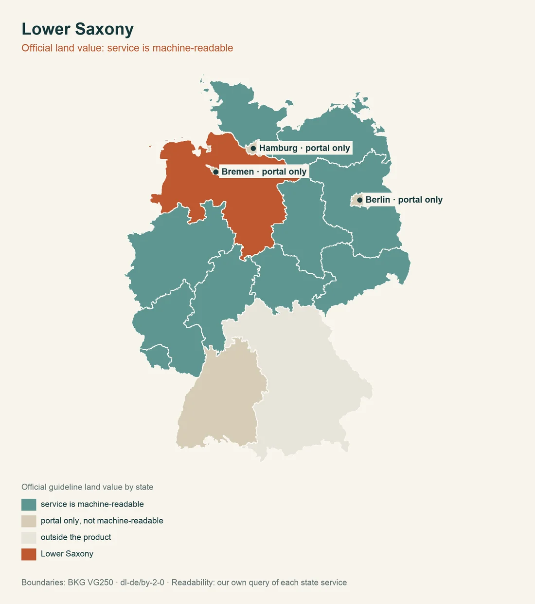
Section 196 BauGB sets the federal framework. The official Lower Saxony real estate market portal provides Bodenrichtwert information online free of charge; BORIS.NI is the state-specific access point. The map value remains a zone value and does not replace checks of planning law, servicing and encumbrances.
The Niedersächsische Landesgrundstücksmarktbericht reports an average building plot for individual residential construction of 129 euros per m² in both 2023 and 2024. The Statistical Pocketbook reports an average purchase value for serviced building land in 2024 of 148.01 euros per m². The figures use different statistical definitions and are not a price for the individual parcel.
The Bodenrichtwert and land value guide explains the comparison logic. In Lower Saxony, the regional position in the state market report must also be considered.
Check watercourses by their legal class
Section 58 Abs. 1 NWG does not use one uniform inner-area value. For first-order watercourses, the source gives 10 m. For second-order watercourses, the state-law special rules and regulatory areas must be checked. For third-order watercourses, § 58 gives 3 m; in areas with a high density of watercourses, a smaller variant may apply, but it is at least 1 m wide.
The Niedersächsisches Wassergesetz provision must therefore be read against the actual watercourse rather than a blanket map. The available official source does not establish one uniform inner-area value. The municipality, water authority and Bebauungsplan remain relevant.
Contaminated sites, mining and unexploded ordnance
Under § 6 NBodSchG, the lower soil protection authorities maintain the Altlastenverzeichnis, the register of contaminated-site information, with location, condition, measures and monitoring information. Owners, prospective buyers and other people with a legitimate interest may request information; the request is subject to a fee. The LBEG information does not confirm general public online access to every parcel record.
Under §§ 69 and 75 BBergG, LBEG is the mining authority for Lower Saxony. The old-mining information system and the Bergarchiv Clausthal-Zellerfeld support a case-specific review.
For unexploded ordnance, responsibility lies with the Kampfmittelbeseitigungsdienst of Lower Saxony at LGLN, Regionaldirektion Hameln-Hannover. The aerial-image assessment requested from the service is fee-based under the official application document. Information about suspected explosive remnants belongs in the file before earthworks.
Heritage protection and find risk
Under §§ 1, 4 and 21 DSchG,NI, entry in the register is generally declaratory. Protection does not depend only on entry; the same applies to archaeological monuments. Section 18 DSchG,NI provides, under its stated discovery conditions, for ownership of movable monuments to pass to the state. The confirmed start of this rule is 1 April 1979.
The Denkmalatlas Lower Saxony is the first map check. The Niedersächsisches Landesamt für Denkmalpflege maintains the register professionally; municipalities, districts and independent cities participate as lower heritage authorities. The official DSchG text provides the legal basis.
Agricultural land and neighbours
Section 1 NGrdstLwG sets the standard Lower Saxony threshold: transfers of land below 0.5 ha generally require no approval under the GrdstVG. For acquisition by a municipality or a recognised nature conservation association, the law names a special threshold below 1 ha. For larger agricultural parcels, the approval route must be clarified before purchase.
Sections 27 and 50 NNachbG regulate fencing and vegetation distances. The plant-distance scale is: up to 1.2 m high, 0.25 m; up to 2 m, 0.50 m; up to 3 m, 0.75 m; up to 5 m, 1.25 m; up to 15 m, 3 m; and above that, 8 m. Section 27 generally creates a fencing duty, subject to statutory and local conditions, for built-up or commercially used neighbouring land.
The Niedersächsisches Nachbarrechtsgesetz must be read together with local custom and local building by-laws.
Forest and nature-conservation pre-emption
Under § 12 Abs. 4 NWaldLG, converting forest to another land use generally requires approval. If no natural regeneration has developed after three years, the forest owner must reforest the area. The forest provision matters before buying forest or a forest-edge parcel.
Section 40 NNatSchG can supplement § 66 BNatSchG by establishing a state pre-emption right through an ordinance in certain nature reserves. The state pre-emption provision belongs in the review when the plot lies in a protected area.
- Planning lawMunicipality or building authority
- Parcel and mapGeoportal Niedersachsen
- Soil, value and hazardsSpecialist portal and competent authority
Source: NBauO; Geoportal Niedersachsen; BORIS.NI; Altlastenverzeichnis Niedersachsen; checked August 2026
Taxes, property tax and fees
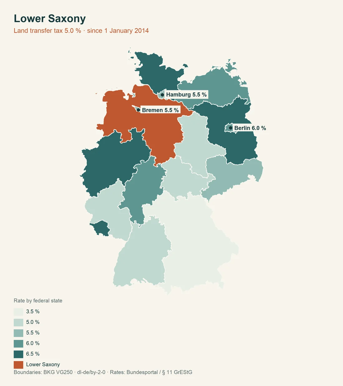
Real estate transfer tax in Lower Saxony is 5 percent and has applied since 1 January 2014. Section 1 Abs. 2 GrEStFG,NI is decisive; the state-law provision documents the rate.
For Grundsteuer B, property tax B, Lower Saxony uses the area-location model under the NGrStG. The municipality sets the multiplier, which must be distinguished from the state-law assessment model. The Lower Saxony tax administration explains the model.
Section 1 BauGO provides the state-law fee framework for building-control acts. The Baugebührenordnung gives the framework but no confirmed current commencement date for the complete text. The actual fee must be clarified with the building control authority.
Documents to collect before signing
The purchase file for Lower Saxony should answer at least these state-specific questions:
- Does the planned building geometry fit 0.5 H and the special rules in § 5 NBauO?
- Does the plot meet § 62 NBauO, and has the municipality confirmed secured servicing?
- Is there an extract from the Baulastenverzeichnis alongside a separate Grundbuch check?
- Which ALKIS information product is needed, and what fees apply?
- Which watercourse class, contaminated-site, mining and ordnance indications affect the land?
- Do the Denkmalatlas, NNatSchG, forest law, NNachbG or NGrdstLwG apply?
Check the parcel before purchase. The property check connects planning law, registers and location factors.
Municipal confirmation remains decisive
Many Lower Saxony rules do not end at the state portal. The Lower Saxony geodata office and the Geoportal provide data, but the municipality confirms the legally binding version of the Bebauungsplan. The same applies to secured servicing in the procedure under § 62 NBauO.
The state authorities divide the work: LGLN explains ALKIS, the Gutachterausschusswesen explains the market report and the Niedersächsisches Vorschrifteninformationssystem provides the statutes. For a practical decision, the competent municipal or district authority is still the final contact.
This division explains why one portal image is not enough. A parcel may be visible in the Bodenrichtwert portal while a Baulast, water distance, contaminated-site notice or municipal by-law appears only after a request. Requests should state the parcel number, municipality and intended use.
For pre-purchase planning, the comparison of setback distances in all 16 German states shows how boundary distances differ; the comparison of public-law building obligations across Germany places public-law obligations in context.
Involve the municipality early. The property check keeps outstanding confirmations separate from state facts that are already documented.
Organise the file by municipality and parcel
State-law information becomes reliable only when assigned to the correct parcel. For a building plot, every request should therefore include the parcel number, municipality, cadastral district and status of the planning documents. This makes it possible to identify later whether an answer really concerns the offered land.
This is particularly important for § 58 NWG. A third-order watercourse with a possible width of 3 m, or at least 1 m in special areas, requires a different review from a first-order watercourse with 10 m. The number alone is not decisive; the watercourse class and special area must be documented.
For agricultural land, the threshold of 0.5 ha must not be confused with a general buildability rule. Section 1 NGrdstLwG concerns approval requirements in land transactions. Planning law, nature conservation and forest law remain separate questions.
Even with a favourable purchase price, due diligence can be economically sensible. A contaminated-site notice, a fee-based ordnance assessment or a missing Baulast extract does not automatically alter the calculation by a fixed amount, but it creates open risk. Before notarisation, that risk should be assigned to a competent authority.
For planned road works, the comparison of road improvement contributions in all 16 German states helps classify state contribution duties. It replaces neither the request under § 81 NBauO nor the municipal confirmation under § 62 NBauO.
Do not hide risks in the purchase price
A state-law feature is rarely the sole reason for a purchase decision. Its meaning comes from the connection with the parcel: a 0.5 H setback can shift the desired footprint, § 62 NBauO can require municipal confirmation, and § 81 NBauO can reveal a public-law obligation.
For a plot beside water, in the outer area or in a protected area, the request to the competent office should be made before the notary appointment. The sources confirm the rule, but not automatically the condition of the individual parcel.
Answers should be filed with date, parcel and contact person. That makes later coordination between municipality, building control, cadastral office and specialist authority easier.
That is how a state comparison becomes a concrete decision: the statute describes the framework, the municipality confirms the plan and the specialist authority answers the parcel-specific risk.
This allocation is particularly useful with multiple owners, partial areas and edge locations.
A short file note prevents later mix-ups.
It is the quickest route to a defensible file.
Related state-law checks also refer to § 1 Abs. 2 GrEStFG,NI, § 18 DSchG,NI, § 27 NNachbG, § 40 NNatSchG, § 58 Abs. 1 NWG and § 196 BauGB.
Sources and date
Information current as of 6 August 2026. The information is general and does not replace advice from the municipality, building control authority or specialist authority. Further reading: Bodenrichtwert, public-law building obligations, contaminated sites and soil contamination and access and infrastructure.