
Value and price
Bodenrichtwert: valuing German land
Each German state publishes official land values for locations, updated on its own schedule. Reading it correctly is the cheapest price check a buyer can make.
On this page
An official price, free to everyone
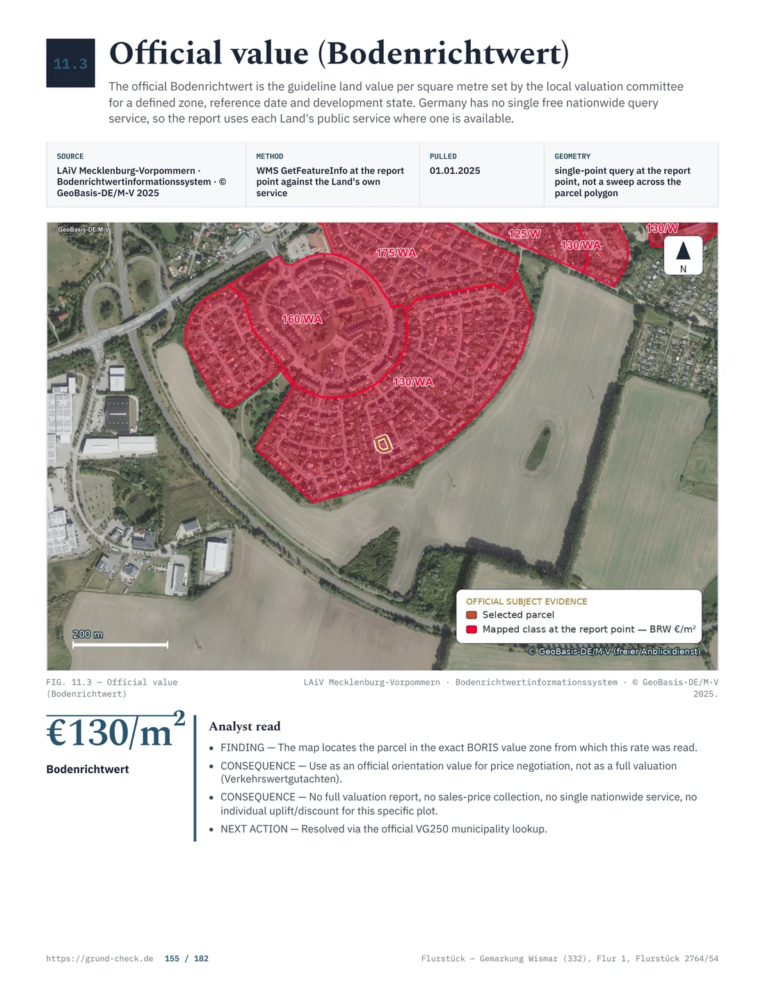
Germany publishes what land is worth. Federal law defines the valuation framework. State law supplies the official data and reference dates, while a municipal by-law may use the figure for local charges. For every location there is a Bodenrichtwert, an official average value per square metre, and § 196 Abs. 3 BauGB requires it to be published and lets anyone ask for it. The values are available free of charge and without registration in the relevant state’s BORIS portal, with the history alongside the current figure.
The result is that no buyer using the portal has to guess what a location costs. An asking price can be compared against an official figure in ten minutes. The reason people still overpay is not that the data is hidden but that the figure is routinely read as something it is not.
Who produces it and how often
The values are determined by the Gutachterausschüsse für Grundstückswerte, independent committees established under § 192 BauGB. Their basis is the Kaufpreissammlung under § 195 BauGB: every notarised purchase contract in Germany is sent to the committee, so the values come from actual transactions rather than from asking prices.
§ 196 BauGB requires determination at least every second year, and the relevant state does it annually, to the reference date of 1 January. One recent change matters for rural buyers: since 1 January 2025 the values for forest land no longer include the standing timber, only the bare land.
Compare the asking price with the official figure. A GrundCheck preflight report locates the parcel precisely, which is what makes a land value lookup meaningful rather than approximate. Check a parcel.
What the figure actually describes
A Bodenrichtwert is the average locational value of the land for a majority of plots inside a defined zone, expressed per square metre and referring to a notional plot with stated characteristics. Those characteristics are published with the value and they are the part buyers skip.
The notional plot has a defined use, a defined density, a typical size and shape and a defined state of Erschließung (legal access and servicing). A value marked erschließungsbeitragsfrei assumes the contribution has been paid; one marked erschließungsbeitragspflichtig does not. Comparing a plot whose road charge is still outstanding against a value that assumes it has been paid overstates what the plot is worth by the whole amount of the future bill.
What it is not
It is not a valuation of your plot. § 199 BauGB and the ImmoWertV 2022 set out how a value is actually derived, and the land value is one input among several. It is not a ceiling or a floor for the price, since a well-informed market can transact above or below it. And it is not evidence in a negotiation on its own, because the seller can point to the same figure and to the differences of the specific plot.
Nor does it capture the building on the plot. The Bodenrichtwert is a value for the ground alone, so on a parcel with a house the land value answers only half the question, and on a parcel with a derelict building it may overstate the position, because demolition is a cost the buyer carries. Where a structure is present, price the land from the zone value and the building separately, and treat the demolition estimate as a deduction rather than as a detail.
What it does give you is a defensible starting point and, more useful still, a series. Five years of values for the same zone show whether a location is rising, flat or falling, and that trend is often a better guide to a decision than the current number.
Adjusting for the plot in front of you
The zone value describes the notional plot. Yours is different, and four differences carry most of the adjustment.
- Size. A plot much larger than the local norm rarely fetches the full rate per square metre for the surplus, because the extra ground has no separate use.
- Shape and frontage. A narrow or awkward plot takes less building than its area suggests once the setbacks are drawn.
- Density. Where the permitted GRZ or GFZ differs from the notional plot's, the value moves with it, since the buyer is buying what can be built.
- Erschließung. Outstanding contributions come off the price, at full value.
Add the plot-specific burdens on top: easements, Baulasten, contamination, protected trees. Each of those is a deduction and each is documented elsewhere, which is why the value check comes after the register work rather than before it.
Source: Upper Valuation Board for Property Values in Brandenburg, Property Market Report 2025; checked August 2026
The 2025 state figures
Brandenburg's state market report for 2025 puts the state average value of building land at 219 € per square metre. The spread is what matters: roughly 318 € in major-city ring municipalities, and about 111 € in the wider region beyond it (market report 2025). A plot two hours from a major city and a plot in a rural district are different markets, not different prices in one market.
Those averages hide the movement that matters to a buyer. A location an hour out that gains a reliable rail connection behaves differently from one that does not, and the annual series in BORIS shows which of the two you are looking at long before it shows up in an asking price.
Agricultural and forest land runs in a different order of magnitude entirely: 1.17 € per square metre for cropland, 0.87 € for grassland and 0.71 € for forest. Farmland transacted at 13 218 € per hectare in 2024 according to the statistical office. That ratio, roughly two hundred to one between building land and cropland, is the whole financial content of the buildability question.
Reading a BORIS entry properly
Open BORIS state portal, find the parcel, and read four things off the entry rather than one. The value and its reference date. The Entwicklungszustand, which says whether the zone is building land, Bauerwartungsland, Rohbauland or agricultural land, and those are very different things. The Erschließungsbeitragszustand. And the notional plot's use and density.
The zone boundaries matter as much as the value. A Bodenrichtwertzone covers an area the committee regards as broadly uniform, and a parcel at the edge of one can sit next to a very different figure across the line. Where the plot lies at a boundary, look at both zones and ask which of the two the parcel actually resembles, since the map is a generalisation and the committee draws it for a majority of plots rather than for yours.
Bauerwartungsland deserves particular care. It means land that may become building land, priced above farmland and far below serviced plots, and the expectation may take a decade to be realised or may never be. A seller quoting a building-land value for a Bauerwartungsland zone is quoting the wrong figure, and the entry itself shows it.
- Read the zoneValue, reference date and development state
- Match the parcelArea, shape and development plan
- Check infrastructureDeduct outstanding contributions
- Account for burdensLand register and Baulasten
- Use comparable salesPurchase-price collection or valuation
Source: BauGB §§ 192 to 196 and ImmoWertV 2022; checked August 2026
When to buy the committee's report
Two products go beyond the free data. The Gutachterausschuss sells extracts from the Kaufpreissammlung under § 195 BauGB, giving actual transactions comparable to your plot, and it prepares full valuation reports under § 193 BauGB. Both cost money, and both are worth it in the same two situations: a purchase large enough that a few percent matters, and a dispute where an independent figure has to stand up.
Prices for both are set by the committee's fee rules and vary by district, but a purchase price extract is an inexpensive document by the standards of a land purchase, while a full report is a four-figure commission. Ask the district committee what it charges and how long it takes, because in the busy metropolitan districts a report can take longer than the seller is willing to wait.
For an ordinary house plot the free value plus honest adjustments is usually enough. Where the plot is unusual, where the seller's price is far from the zone value, or where a family or tax matter turns on the number, buy the report.
Where the tax office uses the same number
The land value is a market signal and a tax input. It feeds the Grundsteuer assessment through the federal valuation rules, and the property transfer tax is charged on the agreed consideration under § 8 GrEStG at Brandenburg's state rate of 6.5 percent. A land value far above the price agreed in the deed is the kind of thing a tax office notices.
That works both ways. A price far below the local value in a transaction between relatives raises the question of a gift, and a price far above it will not be reduced for tax purposes because the buyer overpaid. The costs guide sets out what is payable on a purchase.
Land value against asking price
| State | Verification point |
|---|---|
| Baden-Württemberg | Official state land-value data: consult the current state guide and confirm the applicable official value or rule for the parcel. |
| Bavaria | Official state land-value data: consult the current state guide and confirm the applicable official value or rule for the parcel. |
| Berlin | Official state land-value data: consult the current state guide and confirm the applicable official value or rule for the parcel. |
| Brandenburg | Official state land-value data: consult the current state guide and confirm the applicable official value or rule for the parcel. |
| Bremen | Official state land-value data: consult the current state guide and confirm the applicable official value or rule for the parcel. |
| Hamburg | Official state land-value data: consult the current state guide and confirm the applicable official value or rule for the parcel. |
| Hesse | Official state land-value data: consult the current state guide and confirm the applicable official value or rule for the parcel. |
| Mecklenburg-Western Pomerania | Official state land-value data: consult the current state guide and confirm the applicable official value or rule for the parcel. |
| Lower Saxony | Official state land-value data: consult the current state guide and confirm the applicable official value or rule for the parcel. |
| North Rhine-Westphalia | Official state land-value data: consult the current state guide and confirm the applicable official value or rule for the parcel. |
| Rhineland-Palatinate | Official state land-value data: consult the current state guide and confirm the applicable official value or rule for the parcel. |
| Saarland | Official state land-value data: consult the current state guide and confirm the applicable official value or rule for the parcel. |
| Saxony | Official state land-value data: consult the current state guide and confirm the applicable official value or rule for the parcel. |
| Saxony-Anhalt | Official state land-value data: consult the current state guide and confirm the applicable official value or rule for the parcel. |
| Schleswig-Holstein | Official state land-value data: consult the current state guide and confirm the applicable official value or rule for the parcel. |
| Thuringia | Official state land-value data: consult the current state guide and confirm the applicable official value or rule for the parcel. |
| Step | Source | Effect on the number |
|---|---|---|
| Zone value per square metre | BORIS, free | starting point |
| Development state of the zone | BORIS entry | decides which market you are in |
| Erschließung state | BORIS plus the municipality | deduct any outstanding contribution |
| Size, shape, density | cadastral map, B-Plan | up or down, often 10 to 30 percent |
| Registered burdens | Grundbuch, Baulastenverzeichnis | deduction, sometimes decisive |
| Comparable sales | Kaufpreissammlung, paid | confirms or corrects the whole calculation |
Verkehrswert, Beleihungswert and the bank
§ 194 BauGB defines the Verkehrswert, the market value: the price that would be achieved in ordinary business dealings at the valuation date, according to the legal circumstances and actual characteristics of the property, disregarding unusual or personal circumstances. That is the figure a valuation aims at, and the land value is one route towards it.
A lender works with a different number. The Beleihungswert is deliberately conservative, set below the market value and meant to hold through a downturn, and the loan is a percentage of that rather than of the price. A buyer who pays well above the local land value therefore meets the gap twice: once in the price, and again in the deposit the bank requires. Checking the zone value before making an offer is as much a financing step as a negotiating one.
Agricultural and forest land is a different market
Farmland and woodland have their own values in BORIS and their own dynamics. Cropland at 1.17 € and forest at 0.71 € per square metre are not small versions of building land prices; they reflect what the ground yields, and they respond to lease levels, subsidy rules and timber prices rather than to commuter distance from a major city.
Two Brandenburg-specific points belong with the figures. In Brandenburg, sales of agricultural land above two hectares need approval under the Grundstücksverkehrsgesetz, and the approval can be refused where the sale is regarded as an unhealthy distribution of land, which is a real constraint on non-farming buyers. And since 1 January 2025 the forest values in BORIS exclude the standing timber, so the timber on a wooded parcel has to be valued separately. The forest guide covers that valuation.
What else the committee publishes
The land values are the visible part of a larger body of work. Under § 193 BauGB the committees also produce market reports, and those reports carry the material that turns a zone value into a defensible price: conversion factors for plot size and density, comparison factors, the number and volume of transactions in each district, and the direction the market moved.
For the state used in these figures, the state-level report is published each summer, and the district committees publish their own. Reading the section for the district you are buying in takes half an hour and answers the question a single zone value cannot: whether the location is trading at all. A zone with three sales a year is a thin market, and a thin market makes any single figure less reliable.
Turning the figure into an offer
The value check is worth writing down, because a seller argues with an opinion and rarely with a calculation. One page is enough: the zone value with its reference date and development state, the plot's area, the adjustments for size, shape, density and Erschließung with a reason for each, and the deductions for burdens found in the two registers.
Keep the arithmetic visible. If the zone value is 150 € per square metre, the plot is 900 square metres, and the outstanding road contribution is 12 000 €, the starting figure is 135 000 € and the adjusted one 123 000 € before any further deduction. Numbers written out this way survive being forwarded to a partner, a bank or a lawyer, which a conversation does not.
The result is a number and, more importantly, a list of the things the price depends on. Where the seller disputes a deduction, the discussion is about that item rather than about the whole price. Where an item is uncertain, it becomes a condition in the deed instead of a discount. Buyers who work this way tend to pay less and, more usefully, know why.
Three ways buyers get it wrong
Multiplying the value by the area. The zone value describes a notional plot. Multiplying it by 3 000 square metres of garden land at the edge of a village produces a number no valuer would defend.
Ignoring the development state. Paying building-land prices for Bauerwartungsland can produce a substantial valuation error, and the BORIS entry identifies the development state explicitly.
Treating the value as the price. The value is an average of the past around a location. The price is what this plot, with its access, its burdens and its ground conditions, is worth to a buyer who has done the work.
Price the plot, not the postcode. Order a GrundCheck preflight report and set the official land value against what the parcel itself allows before making an offer. Check a parcel.
Where these rules are written
- Committees, purchase price collection and land values: § 192, § 193, § 194, § 195, § 196, § 197 and § 199 BauGB.
- Valuation method: ImmoWertV 2022.
- State data: BORIS state portal, the Gutachterausschuss, the market report 2025, and land price statistics from the statistical office. The state comparison cites § 1 LStatG BW; Art. 1 Bayerisches Statistikgesetz; § 2 Statistikgesetz Berlin-Brandenburg; § 1 NStatG; and § 3 Statistikgesetz NRW.
- Taxes that use the figure: § 8 GrEStG and the applicable state rate under the state rate law.
Rules and figures were checked in August 2026. This is general information for buyers, not a valuation of your parcel. Read next: buildability, costs and fees and the due diligence checklist.
What differs between states
Each state publishes valuation data through its own BORIS service and applies its own release schedule and data presentation.
Which level of government sets the rule?
Federal law defines the valuation framework; state services publish the official data, and municipalities apply local planning rules.